PRECISION AGRICULTURE
Precision agriculture (PA) is a farming management concept based on observing, measuring and responding to inter- and intra-field variability in crops.
- Category: Crop Systems Products
Description
Precision agriculture (PA) is a farming management concept based on observing,measuring and responding to inter- and intra-field variability in crops. Precision Agriculture is no longer a new term in crop production. It is now a widely accepted practice. Aerial imagery is a key component in utilizing precision agriculture techniques for the management of farmland. Imagery does not replace the need for crop scouting. Instead, it directs growers to areas of the field that require ground-truthing – which aids in the interpretation and analysis of what is being sensed.
CROP MONITORING FROM ABOVE
Satellite imagery is one of the most valuable tools in precision agriculture today and with imagery every 5 days (cloud dependant), farmers can easily detect changes over time.Detecting changes, helps identify management issues that may be easily fixed or avoided in the future - for example, uneven spreading or spray misses - and for monitoring on-farm trials. The early and timely detection of any potential negative effect on the crop is the main objective of Satelite imagery. It also alow the user to compare realtime senarios and data with data of up to 5 years back.
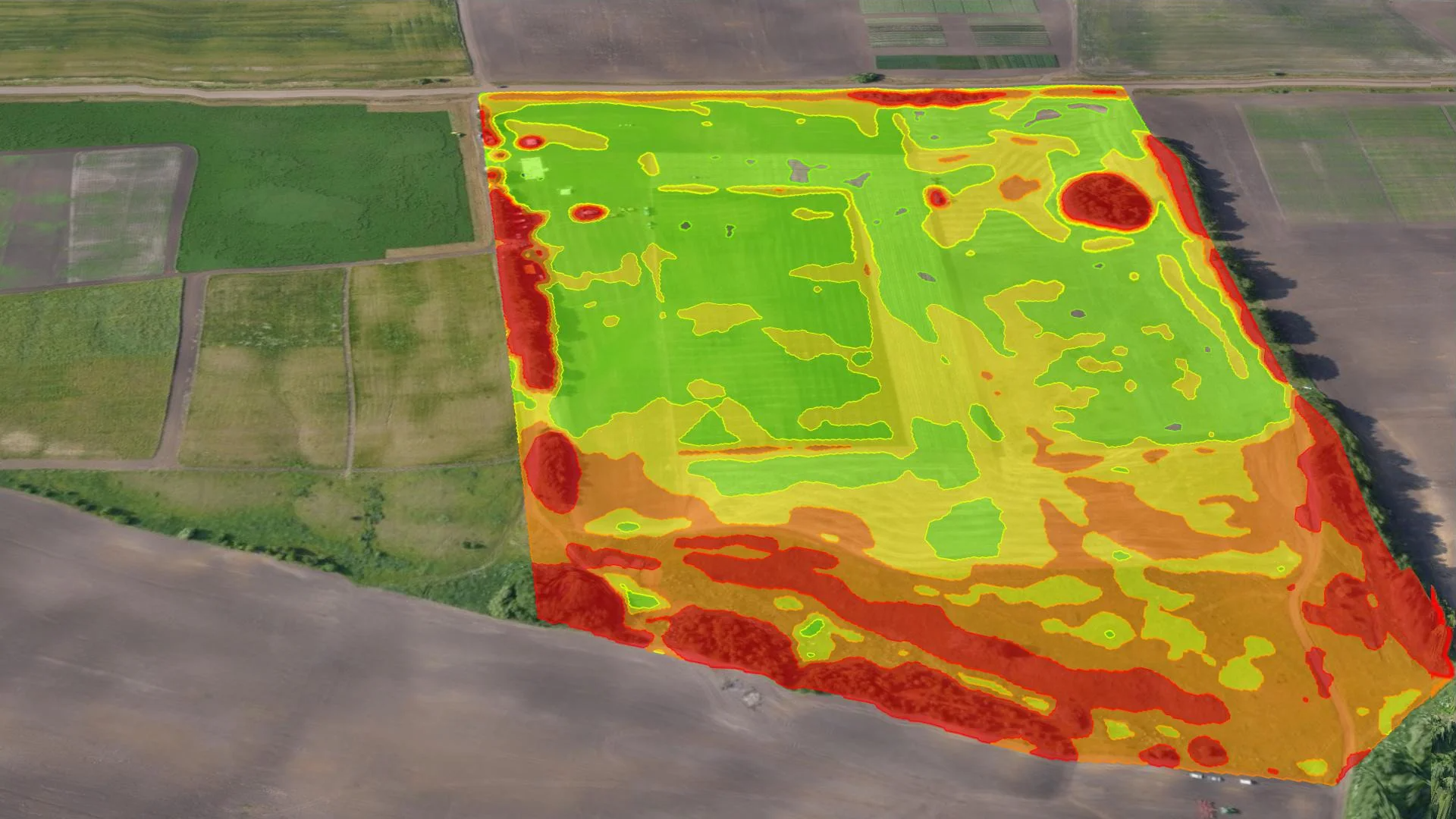
NDVI MAPS EXPLAINED
A Normalized Difference Vegetation Index (NDVI) is an equation that takes into account the amount of infrared reflected by plants. Live green plants absorb solar radiation, which they use as a source of energy in the process of photosynthesis .Crop Scan is an multi dimensional platform not only allowing the user to view NDVI images but also to view the water holding capacity of the soil up to 20 cm deep, plot soil tests on a grid and manage insect scouting on the farm electronically.
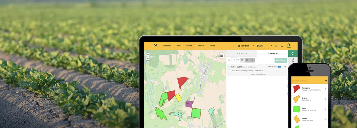
CROPSYSTEMS ONLINE FARMER PORTAL
- Organize your farm’s imagery, maps and records in one Online Farming Portal.
- The Online Portal is user-friendly and secured.
- View your farm on a Map and easily compare imagery of different dates.
- Integrate other maps and data into the portal:
- Farm and Field boundaries, Crop classifications
- Historic imagery
- Productivity Maps (Create Management Zones using historic data to determine where the productivity areas are.)
- Yield Maps and data
- Moisture Maps
- Soil Sampling Maps (Grid or Zoned)
- Laboratory results
- Soil Nutrient Maps
- Drone Imagery
- Topography Maps, etc.
The Dacom online farm management system is truly the world leader in farm managent software platforms.
CROP SYSTEMS MOBILE APPLICATION
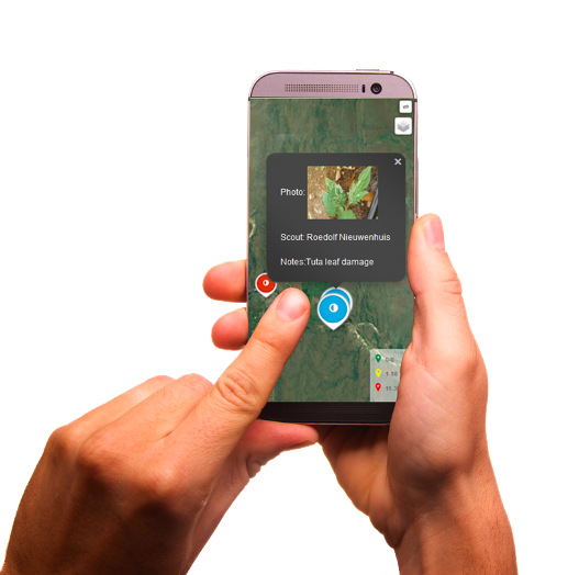
FIELD MAP NAVIGATOR:
- Make use of a Mobile Application which will display a Geo-referenced map of your fields. (Different maps can be used – NDVI imagery, Zone Maps, Topography, Fertilizer etc)
- Navigate to the stress areas using the Mobile application, make observations and share your findings with the rest of the team. Notes and Photos taken in the field will display on your Farming Portal.
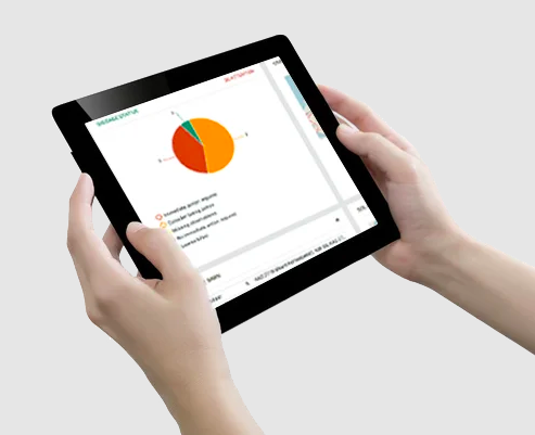
OPTIMISE PEST AND DISEASE CONTROL
- Collect field scouting data via a user friendly mobile scouting application.
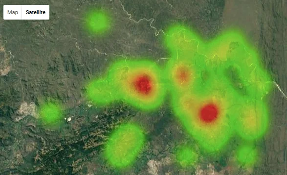
- Visualize collected data on the online portal/Heat maps to quickly identifying outbreaks.
- Report and Respond to received information. Use filters to search for specific criteria like date ranges, pest counts, locations, lure types, scouts, etc. Download Reports or create custom graphs and maps.
CROP RECORDING - SMART FARMING IN THE CLOUD
Crop Recording Management (Crop R) is an online crop management system which brings the agri-food community together, making field recording and data sharing quick, simple and efficient.Farmers are currently frustrated with the masses of paperwork and audits they have to complete to ensure their end produce is marketable. Crop R is a cloud based farm management system for pesticide, fertiliser, agronomy and record keeping, which allows the grower to maintain records on his mobile device or personal computer.
This enables easy transfer of vital crop records, MRL and EurepGap audits among many others allowing hassle free and efficient information to be handed across. Crop R seamlessly integrate with the Dacom disease forecasting and irrigation scheduling software to supply you with one dashboard for all your needs.
KEY BENEFITS:
- Quickly accessible,
- Record and share field activity from any location using our easy-to-use web and mobile apps,
- Avoiding unnecessary duplication of effort and speeding up operational processes,
- Automatic, wireless syncing means that your crop information is available at your fingertips,
- Because your data is stored in the cloud, it’s safe and secure.